


Braess Paradox: Can Adding a Shortcut Increase Travel Time?

We've all been stuck in traffic and wished there were a quicker way to get where we were going. Surely, adding more direct routes or building a shortcut should help? More routes mean more options, and more options should mean less congestion. Right?
Well, not always. At least not when human nature is involved.
Setting the scene
Imagine a road agency trying to improve travel times between two points. A mountain stands in the middle of the landscape, forcing drivers to take one of two long roads around it. The agency has an idea: what if we blasted a shortcut straight through the mountain?
It sounds like a no-brainer. A more direct route should mean less time on the road. But before spending money on a major infrastructure project, it makes sense to test the idea first.
That's exactly what we'll do using an AnyLogic traffic simulation. We'll start with the existing road network, introduce the proposed shortcut, and see whether the results match our expectations.
The existing road network
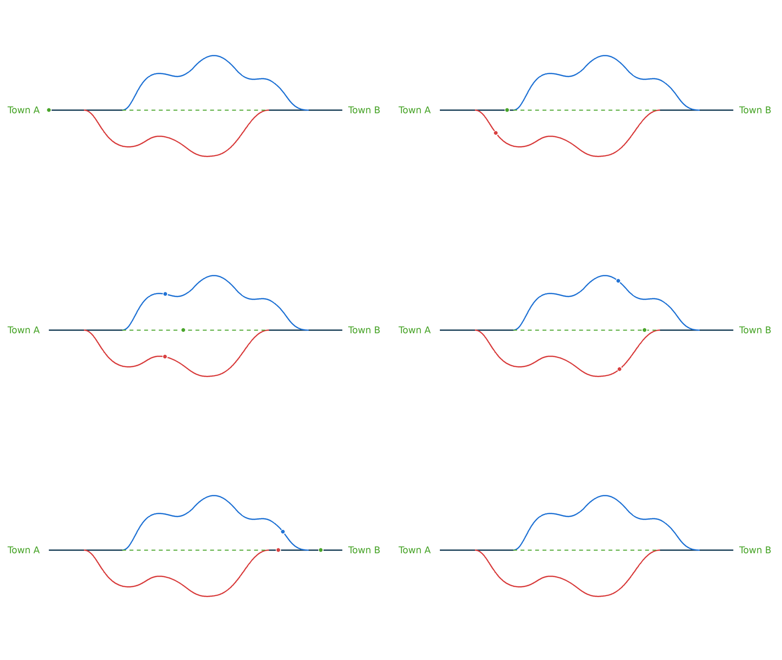
Our model represents a one-way road network connecting an origin to a destination, with a mountain obstructing the direct route between them.
Drivers can travel around the mountain using either the northern or southern route. Both routes include double-lane roads that sweep around the mountain, allowing traffic to spread out across the available lanes. These longer stretches rarely become congested in the simulation.

The existing network: two separate routes around the mountain, each with a single-lane section and a longer double-lane stretch.
However, neither route is entirely made up of double-lane roads. Each has a single-lane section connecting the sweeping road to the area around the mountain.
On the northern route, vehicles travel along a single-lane road before turning onto a double-lane road that winds around the mountain on the north side. On the southern route, they take a double-lane road first around the south side of the mountain, then pass through a single-lane section after the sweeping road.
These are separate routes: the northern and southern roads do not intersect or share these single-lane sections.
That distinction matters. Although the double-lane roads provide plenty of room for vehicles to travel, the single-lane sections can become bottlenecks when traffic builds up.
Establishing our baseline
Before changing anything, we need to understand how the existing network performs.
In the baseline configuration, vehicles are split equally between the northern and southern routes. Each vehicle uses one single-lane section and one longer double-lane stretch to complete its journey.
The model generates both cars and trucks, and traffic lights introduce additional delays at key points in the network. This gives us a more interesting scenario than simply comparing road distances: journey time depends on how vehicles move through the network and whether congestion develops.
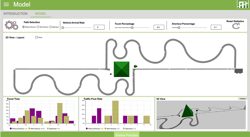
For this experiment, we set the vehicle arrival rate to 5 vehicles per minute and the truck percentage to 50%. Cars travel at 30 km/h and take up 5 meters of road, whereas trucks take up 10 meters of road and travel at 15km/h.
After running the simulation, the average travel time is 5.09 minutes.

This gives us a reference point for evaluating the proposed shortcut. If the new road is going to be worth building, we'd hope to see that average fall.
The proposed shortcut: Surely this will help?
The road agency now proposes blasting through the mountain to create a direct connection between the single-lane sections on either side.
The new shortcut could be a multi-lane road, so it might appear to offer plenty of capacity. It also removes the need to travel along the long double-lane road around the mountain.
At first glance, this seems like a clear improvement. Vehicles would have a more direct route, and the new connection could reduce the distance they need to travel.
But there's a catch. We will get to this catch shortly, but first let's run the model with the shortcut and look at the results.
The result
With the shortcut enabled and all vehicles directed through the central route, the average travel time rises from 5.09 minutes to 22.26 minutes.

The answer is not what we expected!
That's more than four times the original average journey time.
Instead of making journeys faster, the shortcut produces a substantially worse result. The new road is more direct, but the overall journey is slower.
So what is going on? How can adding a road make traffic worse?
Introducing Braess's paradox
This counterintuitive result brings us to Braess's paradox, a phenomenon in traffic network theory in which adding a road can make travel times worse under certain conditions.
In the classic paradox, drivers choose their own routes; in our model, we use prescribed route allocations to illustrate the congestion effect.
Drivers generally want to minimize their own travel time. When a new connection becomes available, it may look attractive to many of them. If enough drivers make the same choice, their combined decisions can create congestion and produce a worse outcome for the network as a whole.
The key idea is that the best route for an individual driver is not necessarily the best arrangement for the entire traffic system.
This is the catch in our model. Remember those single-lane sections? On the original network, a vehicle traveling north uses the northern single-lane section, while a vehicle traveling south uses the southern one. Each route passes through only one of these bottlenecks.
The shortcut connects the two single-lane sections.
A vehicle travelling through the shortcut must now use both: one single-lane section to reach the shortcut and another to leave it. Instead of avoiding the bottlenecks altogether, the shortcut links them into a route that exposes vehicles to both.
If enough vehicles use this more direct connection, congestion can build up on the single-lane approaches to and exits from the mountain. A multi-lane shortcut cannot eliminate delays that develop on the narrower roads feeding into it.
And because humans haven't evolved to share a hive mind, drivers don't know what everyone else is planning to do. Each person makes their own decision, choosing the route they expect will get them to their destination fastest.
The shortcut looks like the obvious choice. But when everyone thinks the same way, the single-lane roads leading into and out of the mountain become congested, slowing the entire journey down.
Here's where the self-fulfilling prophecy comes in. Once congestion builds on both sides of the mountain, switching back to an outside route doesn't necessarily help. Drivers who abandon the shortcut still have to travel along one of those congested single-lane sections, but they also have to cover the additional distance around the mountain. Their journey could be even longer than if they had stayed on the shortcut.
This is closely related to the concept of a Nash equilibrium. In a traffic network, an equilibrium is reached when no individual driver can improve their own journey by changing routes unilaterally, assuming everyone else keeps their routes unchanged. Counterintuitively, that equilibrium can have longer travel times than the equilibrium in a network without the new connection.
Individually, sticking with the shortcut makes sense. Collectively, it leaves everyone worse off.
Each driver is making a seemingly rational decision, but when everyone makes the same choice, the result is a traffic pattern that nobody would choose if they could coordinate as a group.
Our model illustrates the broader issue of how a shortcut and the traffic distribution it creates can affect journey times.
There is an important distinction, though: our current experiment forces all vehicles to use the shortcut in the second configuration. It does not independently simulate drivers choosing routes based on their own travel times, so it does not reproduce the classic selfish-driver equilibrium directly.
It does show why a more direct connection is not automatically a better solution. The road network's layout, the single-lane bottlenecks, and the way vehicles are allocated to routes all matter.
So, rather than immediately abandoning the shortcut, let's ask a different question: could we keep the shortcut but control how many vehicles use it?
Can we do better? Introducing the optimized configuration
The road agency has learned that simply sending every vehicle through the shortcut is a poor strategy in this model. Perhaps the answer is not to remove the new road, but to distribute traffic more carefully.
For the third configuration, we introduce an Optimised option.
Instead of directing all vehicles onto the shortcut, we allow only a small proportion to use it. But how could this be implemented in the real world?
One option is to introduce a toll or congestion charge for using the shortcut. By adjusting the price, the road agency could discourage unnecessary use while keeping the route available for drivers who are willing to pay for the time saved, particularly when they're in a hurry or responding to an emergency.
This is the principle behind London's Congestion Charge, which aims to discourage certain journeys into central London by making them more expensive, helping to manage traffic demand. While the charge doesn't guarantee a particular percentage of drivers will use a route, it illustrates how pricing can influence travel behavior rather than relying on road closures alone.
The goal isn't necessarily to keep drivers off the shortcut altogether. It's to strike a balance: preserve the benefit of having the road available without allowing demand to overwhelm the surrounding network.
The remaining traffic continues to travel around the mountain on the northern and southern routes.
For this experiment, 10% of vehicles use the shortcut, while the other 90% are split equally between the external roads. This means 45% of vehicles use each external route.

The idea is straightforward: keep the shortcut available without concentrating the entire traffic flow on the single-lane approaches that feed into it.
Comparing the results
With the optimized configuration running, the average travel time falls to 5 minutes.
Here are the results from the three configurations:
Configuration | Average travel time |
Without Shortcut | 5.1 minutes |
With Shortcut | 22 minutes |
Optimised | 5 minutes |

The difference is striking.
Compared with the all-shortcut configuration, the optimized arrangement reduces average travel time by approximately 77%. However, the improvement in the overall average compared with the original network is marginal, at around 2% - but still a win.
The marginally improved average hides an interesting trade-off. By limiting shortcut usage to just 10% of vehicles, the wider network benefits from reduced congestion, while those who do use the shortcut enjoy a much faster journey. Their average travel time drops to just 4.19 minutes, compared with the 5.09-minute average in the original network.
In other words, the collective wins through less congestion, while the drivers willing to pay to use the shortcut get an even bigger individual time saving. The key isn't simply adding more road capacity; it's managing how that capacity is used.
Conclusion
The road agency began with a reasonable assumption: adding a shortcut through the mountain should reduce travel times.
But the simulation told a different story.

The baseline network produced an average travel time of 5.09 minutes.
Directing all vehicles through the shortcut increased that average to 22.26 minutes. Restricting shortcut use to 5% produced the best result, at 5 minutes.
The important lesson is not that shortcuts are always bad. It is that a road's usefulness depends on the surrounding network. A multi-lane shortcut may look attractive, but if it connects single-lane sections that become bottlenecks, the resulting journey can be slower than taking a longer route.
Braess's paradox gives us a reason to question the assumption that more infrastructure must mean better performance.
Why Simulation?
The shortcut looked promising because we considered the road itself. The simulation made us consider the system around it.
That is why simulation matters before implementation. We cannot always predict which interactions will overturn an apparently sensible idea. A shorter route, an extra machine or a new operating rule may change where demand accumulates and how the rest of the system performs.
A model gives us somewhere to challenge those assumptions, investigate unexpected results and compare alternatives before committing resources. Its results still need checking against reality, but discovering a problem in a simulation gives us the opportunity to redesign the proposal before people have to live with it.
Simulation gives us a practical way to test proposed changes, observe unexpected outcomes, and explore alternatives before committing to expensive real-world projects.
Sometimes, improving a transport network isn't about adding more roads. It's about understanding how the roads work together.
The example model can be viewed on the AnyLogic Cloud here: https://cloud.anylogic.com/model/9e6a165f-acd4-4d78-ae1b-d5d08e8f373a
Devon Cowling is a simulation engineer and data scientist working with The AnyLogic Modeler. To contact him, use LinkedIn.
With contributions from Selaelo Kgoale
What next?
If you liked this post, you could read more posts by following the links above. Why not subscribe to our blog or follow us on any of the social media accounts for future updates? The links are in the Menu bar at the top, or the footer at the bottom. You can also join the mobile app here!
If you really want to make a difference in supporting us please consider joining our Patreon community here.
If you want to contact us for some advice, maybe a potential partnership or project or just to say "Hi!", feel free to get in touch here, and we will get back to you soon!


Comments